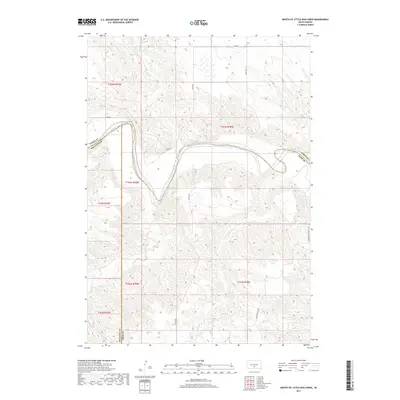
2017 Map of Mouth of Little Dog Creek
USGS Topo · Published 2017About this map
The White River meanders prominently across this South Dakota landscape, carving a deep valley that serves as the boundary between Lyman and Mellette counties. This 2017 survey captures a remote ranching region characterized by sharp topographic relief, particularly near the Pahapesto Buttes in the southeastern quadrant. The drainage network is complex, with several seasonal tributaries including Little Dog Cr, Sedlano Cr, and Oak Cr feeding into the main river channel. Transport is limited to a sparse grid of section-line roads such as 252nd St and the winding River Rd, which follows the river's northern bench. The map provides a precise look at the Public Land Survey System divisions, documenting the township and range intersections where Mellette, Lyman, and Tripp counties converge.
Find a feature on this map
19 named features on this map. Tap any name to fly to it.
Don’t see what you’re looking for? This feature index may not catch every label — zoom into the map to look around manually.
Map Details
Editions of this 2017 Mouth of Little Dog Creek Map
This is the sole edition of this map. No revisions or reprints were ever made.
Other maps of this area

1951 · Badnation
USGS Topo · 1:24,000

1951 · Presho 4 NE
USGS Topo · 1:24,000

1951 · Presho 4 NW
USGS Topo · 1:24,000

1955 · Martin
USGS Topo · 1:250,000

1958 · Martin
USGS Topo · 1:250,000

1972 · Vivian SE
USGS Topo · 1:24,000
1978 · Presho SE
USGS Topo · 1:24,000

1978 · Presho SW
USGS Topo · 1:24,000

1982 · Presho 4 SE
USGS Topo · 1:25,000

1982 · Two Nation Creek
USGS Topo · 1:25,000