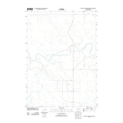
2012 Map of Mouth of Mission Creek
USGS Topo · Published 2012About this map
The White River carves a meandering course through the southern South Dakota plains, serving as the dominant hydrological feature of this Tripp County landscape. This drainage basin is defined by several significant tributaries, including Mission Cr and Cottonwood Cr, which cut through the high ground to join the main river. The area's transportation network is anchored by Route 183, which runs north-to-south and crosses the river, connecting rural sections along a rigid grid of local roads such as 252nd St and 260th St. This 2012 survey illustrates the relationship between these prairie watercourses and the modern infrastructure designed to traverse them, showing the placement of stream crossings and the relative isolation of the river's floodplains from the primary road corridors.
Find a feature on this map
12 named features on this map. Tap any name to fly to it.
Don’t see what you’re looking for? This feature index may not catch every label — zoom into the map to look around manually.
Map Details
Editions of this 2012 Mouth of Mission Creek Map
This is the sole edition of this map. No revisions or reprints were ever made.
Other maps of this area

1951 · Presho 4 NE
USGS Topo · 1:24,000

1951 · Ideal NW
USGS Topo · 1:24,000

1951 · Presho 4 NW
USGS Topo · 1:24,000

1955 · Martin
USGS Topo · 1:250,000

1955 · Mitchell
USGS Topo · 1:250,000

1958 · Martin
USGS Topo · 1:250,000

1959 · Mitchell
USGS Topo · 1:250,000

1978 · Kennebec SW
USGS Topo · 1:24,000
1978 · Presho SE
USGS Topo · 1:24,000

1978 · Presho SW
USGS Topo · 1:24,000