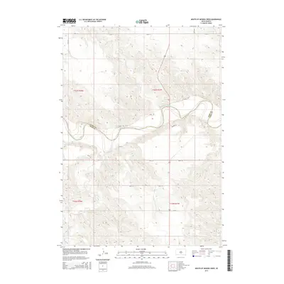
2015 Map of Mouth of Mission Creek
USGS Topo · Published 2015About this map
The White River winds through the northern frontier of the Rosebud country, forming a distinct natural boundary as it flows eastward between Lyman and Tripp counties. This landscape is defined by the convergence of several drainages, including the lengthy Mission Cr and Cottonwood Cr, which carve deep paths through the prairie breaks toward the river valley. The topography reveals a sparsely settled ranching territory where local movement relies on a grid of section line roads like 257th St and named tracks such as Bison Rd and Paradise Rd. The map illustrates the persistent geography of South Dakota's river systems, showing the intricate feeder creeks like Big Ear Cr and Mill Iron Cr that drain the surrounding highlands.
Find a feature on this map
18 named features on this map. Tap any name to fly to it.
Don’t see what you’re looking for? This feature index may not catch every label — zoom into the map to look around manually.
Map Details
Editions of this 2015 Mouth of Mission Creek Map
This is the sole edition of this map. No revisions or reprints were ever made.
Other maps of this area

1951 · Presho 4 NE
USGS Topo · 1:24,000

1951 · Ideal NW
USGS Topo · 1:24,000

1951 · Presho 4 NW
USGS Topo · 1:24,000

1955 · Martin
USGS Topo · 1:250,000

1955 · Mitchell
USGS Topo · 1:250,000

1958 · Martin
USGS Topo · 1:250,000

1959 · Mitchell
USGS Topo · 1:250,000

1978 · Kennebec SW
USGS Topo · 1:24,000
1978 · Presho SE
USGS Topo · 1:24,000

1978 · Presho SW
USGS Topo · 1:24,000