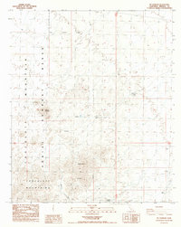
1988 Map of Mt. Barrow
USGS Topo · Published 1988About this map
Chocolate Mountains dominates this desert landscape in Imperial County, where military activity and mining history intersect. The map records the Naval Reservation Boundary and an extensive Gunnery Range that spans much of the western terrain. These designations reflect the strategic use of this arid region in the late 20th century, contrasting with the scattered evidence of early industrial efforts. Evidence of mineral exploration is seen at the Paymaster Mine and various Prospects throughout the range. Topographical landmarks like Sawtooth Mountain and Mt Barrow provide the high points of this surveyed area, while the low-lying Ninemile Wash cuts through the southern reaches. The settlement of Imperial Gables sits at the edge of this transition, providing a small human footprint in a region primarily defined by military training and geological survey work.
Find a feature on this map
15 named features on this map. Tap any name to fly to it.
Don’t see what you’re looking for? This feature index may not catch every label — zoom into the map to look around manually.
Map Details
Editions of this 1988 Mt. Barrow Map
This is the sole edition of this map. No revisions or reprints were ever made.
Other maps of this area

1942 · Blythe
USGS Topo · 1:250,000

1953 · Palo Verde Mountains
USGS Topo · 1:62,500

1953 · Quartz Peak
USGS Topo · 1:62,500

1953 · Chuckwalla Spring
USGS Topo · 1:62,500

1953 · Acolita
USGS Topo · 1:62,500

1954 · Salton Sea
USGS Topo · 1:250,000

1955 · Salton Sea
USGS Topo · 1:250,000

1959 · Salton Sea
USGS Topo · 1:250,000

1963 · Salton Sea
USGS Topo · 1:250,000

1965 · Salton Sea
USGS Topo · 1:250,000