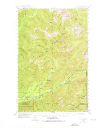
1947 Map of Mt Christie
USGS Topo · Published 1976About this map
The North Fork Quinault River and its numerous tributaries carve through the heart of the Olympic National Park in this 1947 field-checked study. The map documents the backcountry infrastructure of the mid-20th century, notably centered around the North Fork Ranger Station and the Graves Creek Inn. High-altitude routes like the Skyline Trail and the curiously named Underground Passage connect remote peaks such as Mt Christie and Kimta Peak.
Find a feature on this map
66 named features on this map. Tap any name to fly to it.
Don’t see what you’re looking for? This feature index may not catch every label — zoom into the map to look around manually.
Map Details
Editions of this 1947 Mt Christie Map
3 editions found
Other maps of this area

1921 · Quinault Lake
USGS Topo · 1:62,500

1921 · Satsop
USGS Topo · 1:62,500

1935 · Mount Olympus
USGS Topo · 1:62,500

1938 · Mt Constance
USGS Topo · 1:125,000

1939 · Mount Tom
USGS Topo · 1:62,500

1942 · Mount Olympus
USGS Topo · 1:62,500

1944 · Mt. Angeles
USGS Topo · 1:62,500

1946 · Mt. Angeles
USGS Topo · 1:62,500

1947 · Mt. Steel
USGS Topo · 1:62,500

1947 · Mt Christie
USGS Topo · 1:62,500