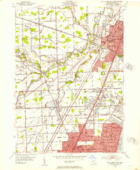
1952 Map of Mt Clemens West
USGS Topo · Published 1953About this map
Mt Clemens and the expanding suburbs of Roseville and St Clair Shores dominate this early 1950s landscape, illustrating the transition from agricultural tracts to structured residential subdivisions. The Clinton River meanders through the center, flanked by local institutions like Berry Hospital and the Courthouse in the county seat. This period of growth is underscored by a dense network of sectional roads such as Sixteenmile Road and Nineteenmile Road, which segment the terrain into distinct neighborhoods like Broad Acres and Couchez.
Find a feature on this map
109 named features on this map. Tap any name to fly to it.
Don’t see what you’re looking for? This feature index may not catch every label — zoom into the map to look around manually.
Map Details
Editions of this 1952 Mt Clemens West Map
2 editions found
Other maps of this area

1905 · Detroit
USGS Topo · 1:62,500

1905 · Grosse Pointe
USGS Topo · 1:62,500

1908 · Rochester
USGS Topo · 1:62,500

1912 · Mt Clemens
USGS Topo · 1:62,500

1918 · Detroit
USGS Topo · 1:62,500

1918 · Grosse Pointe
USGS Topo · 1:62,500

1924 · Detroit
USGS Topo · 1:62,500

1929 · Mt Clemens
USGS Topo · 1:62,500

1934 · Detroit
USGS Topo · 1:62,500

1936 · Warren
USGS Topo · 1:31,680