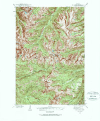
1940 Map of Mt Cowen
USGS Topo · Published 1963About this map
Gallatin National Forest dominates this topographic study, revealing the complex drainage basins of the Boulder River and its forks during the late 1930s. Surveyed by J. L. Lewis, F. H. Purdy, and J. M. Holmes, the terrain is defined by high-altitude features like McKnight Peak, Black Mtn, and The Needles. The map traces numerous water bodies including Jewel Lake, West Boulder Lake, and Bridge Lake, alongside smaller alpine features like Three Alpine Lake Creeks. A network of early trails provides the only human transit through the region, connecting remote points such as Mill Creek Pass and the high-elevation End Lookout. The detail identifies specific meadows and canyons, including Beaver Meadows and the curiously named Frog-to-Death Creek, offering a clear view of the wilderness geography before mid-century changes.
Find a feature on this map
56 named features on this map. Tap any name to fly to it.
Don’t see what you’re looking for? This feature index may not catch every label — zoom into the map to look around manually.
Map Details
Editions of this 1940 Mt Cowen Map
4 editions found
Other maps of this area

1891 · Livingston
USGS Topo · 1:250,000

1893 · Livingston
USGS Topo · 1:250,000

1940 · Mt. Cowen
USGS Topo · 1:62,500

1940 · Mt Wallace
USGS Topo · 1:62,500

1941 · Mt Douglas
USGS Topo · 1:62,500

1942 · Cutoff Mtn
USGS Topo · 1:62,500

1943 · Mt Wallace
USGS Topo · 1:62,500

1943 · Mt Douglas
USGS Topo · 1:62,500

1943 · Mt Cowen
USGS Topo · 1:62,500

1944 · Cutoff Mtn
USGS Topo · 1:62,500