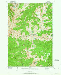
1940 Map of Mt Cowen
USGS Topo · Published 1963About this map
Gallatin National Forest dominates this topographic survey conducted between 1938 and 1940, revealing a high-altitude landscape of the Absaroka Range before mid-century development. The map is anchored by the towering Mt Cowen and the high ridge of The Needles, surrounded by a dense network of glacial basins and alpine waters. Drainage patterns are clearly defined, showing the headwaters of the Boulder River and numerous high-country lakes such as Trapper Lake, Jewel Lake, and Pine Creek Lake. The presence of Meatrack Trail and Mill Creek Pass indicates the established routes used by Forest Service personnel and backcountry travelers during this era. Geologic and natural landmarks like Agate Springs and the descriptively named Froze-to-Death Creek provide specific points of interest for those studying the early mapping of Park County's wilderness areas.
Find a feature on this map
57 named features on this map. Tap any name to fly to it.
Don’t see what you’re looking for? This feature index may not catch every label — zoom into the map to look around manually.
Map Details
Editions of this 1940 Mt Cowen Map
4 editions found
Other maps of this area

1891 · Livingston
USGS Topo · 1:250,000

1893 · Livingston
USGS Topo · 1:250,000

1940 · Mt. Cowen
USGS Topo · 1:62,500

1940 · Mt Wallace
USGS Topo · 1:62,500

1941 · Mt Douglas
USGS Topo · 1:62,500

1942 · Cutoff Mtn
USGS Topo · 1:62,500

1943 · Mt Wallace
USGS Topo · 1:62,500

1943 · Mt Douglas
USGS Topo · 1:62,500

1943 · Mt Cowen
USGS Topo · 1:62,500

1944 · Cutoff Mtn
USGS Topo · 1:62,500