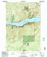
1994 Map of Mt. Defiance
USGS Topo · Published 1996About this map
The Columbia River serves as the central artery for this mid-1990s look at the border between Oregon and Washington, where steep gorge walls separate high mountain lakes from the industrial and recreational nodes along the water. Industry and infrastructure are concentrated on the northern shore near Mill A and the Little White Salmon Nat Fish Hatchery, while the Oregon side highlights a dense network of preservation areas including Starvation Creek State Park and the Mark O Hatfield Wilderness. The landscape is a study in verticality, climbing from the river's edge past the Old Wagon Road to the high peak of Mt Defiance. Water management is evident through the Green Point Upper Reservoir and Green Point Lower Reservoir, illustrating how the region's natural hydrology was harnessed to support the surrounding communities.
Find a feature on this map
85 named features on this map. Tap any name to fly to it.
Don’t see what you’re looking for? This feature index may not catch every label — zoom into the map to look around manually.
Map Details
Editions of this 1994 Mt. Defiance Map
This is the sole edition of this map. No revisions or reprints were ever made.
Other maps of this area

1926 · Hood River
USGS Topo · 1:125,000

1929 · Hood River
USGS Topo · 1:125,000

1953 · The Dalles
USGS Topo · 1:250,000

1956 · The Dalles
USGS Topo · 1:250,000

1957 · The Dalles
USGS Topo · 1:250,000

1957 · Bonneville Dam
USGS Topo · 1:62,500

1957 · Wind River
USGS Topo · 1:62,500

1957 · Willard
USGS Topo · 1:62,500

1957 · Hood River
USGS Topo · 1:62,500
1974 · Parkdale
USGS Topo · 1:24,000