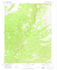
1971 Map of Mt. Dutton
USGS Topo · Published 1974About this map
The high-elevation landscape of the Dixie National Forest is defined by the massive Paunsaugunt Plateau and its complex network of seasonal drainages and springs. Surveyed in the early 1970s, the terrain rises to the prominent peak of Mt Dutton, which is marked by a Radio Tower. The map reveals a high country managed for ranching and forest service operations, evidenced by the Jones Corral Guard Station and scattered water infrastructure like Jones Corral Res and Mule Flat Reservoir. Accessibility in this period was limited to a web of Jeep Trails and Pack Trails, emphasizing the area's isolation and its use for grazing. Significant named points of interest for local history include the remote Winnemucca Spring and the distinctive open spaces of Hootle Flat and Dandelion Flat.
Find a feature on this map
41 named features on this map. Tap any name to fly to it.
Don’t see what you’re looking for? This feature index may not catch every label — zoom into the map to look around manually.
Map Details
Editions of this 1971 Mt. Dutton Map
This is the sole edition of this map. No revisions or reprints were ever made.
Other maps of this area

1885 · Beaver
USGS Topo · 1:250,000

1886 · Kanab
USGS Topo · 1:250,000

1953 · Richfield
USGS Topo · 1:250,000

1953 · Cedar City
USGS Topo · 1:250,000

1958 · Richfield
USGS Topo · 1:250,000

1958 · Cedar City
USGS Topo · 1:250,000

1962 · Cedar City
USGS Topo · 1:250,000

1966 · Bull Rush Peak
USGS Topo · 1:24,000

1966 · Circleville
USGS Topo · 1:24,000
1966 · Junction
USGS Topo · 1:24,000