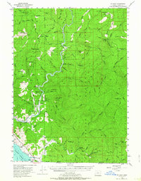
1954 Map of Mt. Emily
USGS Topo · Published 1964About this map
The Chetco River carves a deep valley through the northern reaches of the Siskiyou National Forest, defining the geography of this coastal Oregon interior in the mid-1950s. Settlement is sparse and largely concentrated near the riverbanks and small prairies, evidenced by the Upper Chetco Sch and remote outposts like Tamba Ranch and Bravo Ranch. The map reveals a landscape managed for both preservation and utility, featuring the Alfred A Loeb State Park alongside high-elevation fire infrastructure like the Bear Wallow Lookout. Unusual place names such as Swede Heaven and Pollywog Butte dot the ridges, while the Crisey Airport sits near the coastline just north of the Oregon California state line. This survey captures a specific era of forest management and early recreation prior to more intensive modern development.
Find a feature on this map
103 named features on this map. Tap any name to fly to it.
Don’t see what you’re looking for? This feature index may not catch every label — zoom into the map to look around manually.
Map Details
Editions of this 1954 Mt. Emily Map
3 editions found

Other maps of this area

1917 · Kerby
USGS Topo · 1:125,000

1918 · Kerby
USGS Topo · 1:125,000

1922 · Preston Peak
USGS Topo · 1:125,000

1929 · Crescent City
USGS Topo · 1:125,000

1945 · Kerby
USGS Topo · 1:125,000

1945 · Gasquet
USGS Topo · 1:62,500

1945 · Point St. George
USGS Topo · 1:62,500

1948 · Weed
USGS Topo · 1:250,000

1949 · Eureka
USGS Topo · 1:250,000

1950 · Weed
USGS Topo · 1:250,000