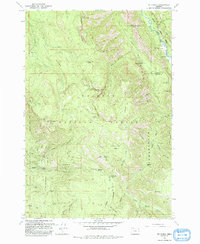
1993 Map of Mt. Fanny
USGS Topo · Published 1993About this map
The Eagle Cap Wilderness dominates this high-country landscape, where the Minam River and Little Minam River carve deep canyons through the Wallowa-Whitman National Forest. Settlement in this remote reach is sparse, focused on the Minam Lodge and its associated Minam Lodge Airstrip and Landing Strip near the confluence of Boulder Creek. The map details a network of 4WD tracks and a Pack Trail system that connects high-altitude landmarks like Pine Butte and Dunns Bluff. This 1990s-era revision illustrates the intersection of recreation and utility, showing the Moss Springs FS Station and Moss Springs Campground alongside telecommunications infrastructure at the Mt Fanny Radio Facility. Topographical features such as Horseshoe Basin and Whiskey Flat define the high ridges between the river forks.
Find a feature on this map
50 named features on this map. Tap any name to fly to it.
Don’t see what you’re looking for? This feature index may not catch every label — zoom into the map to look around manually.
Map Details
Editions of this 1993 Mt. Fanny Map
This is the sole edition of this map. No revisions or reprints were ever made.
Other maps of this area

1906 · Telocaset
USGS Topo · 1:125,000

1955 · Grangeville
USGS Topo · 1:250,000

1959 · Grangeville
USGS Topo · 1:250,000

1965 · China Cap
USGS Topo · 1:24,000

1965 · Fox Point
USGS Topo · 1:24,000

1965 · Union
USGS Topo · 1:24,000

1965 · Cove
USGS Topo · 1:24,000
1965 · Gasset Bluff
USGS Topo · 1:24,000
1965 · Mount Moriah
USGS Topo · 1:24,000

1965 · Little Catherine Creek
USGS Topo · 1:24,000