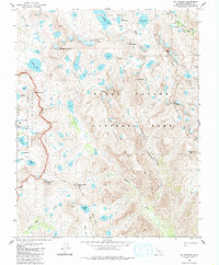
1983 Map of Mt. Goddard
USGS Topo · Published 1986About this map
Mt Goddard dominates this high-altitude landscape within Kings Canyon National Park, where the Goddard Divide meets the Black Divide. This 1980s topography documents a complex drainage network including Wanda Lake in the Evolution Basin and the headwaters of the Kings River. The surveyor's detail captures the challenging routes of the John Muir Trail as it crosses Muir Pass, a vital corridor for Sierra Nevada exploration.
Find a feature on this map
54 named features on this map. Tap any name to fly to it.
Don’t see what you’re looking for? This feature index may not catch every label — zoom into the map to look around manually.
Map Details
Editions of this 1983 Mt. Goddard Map
3 editions found
Other maps of this area

1903 · Tehipite
USGS Topo · 1:125,000

1905 · Tehipite
USGS Topo · 1:125,000

1912 · Mt. Goddard
USGS Topo · 1:125,000

1947 · Mariposa
USGS Topo · 1:250,000

1948 · Fresno
USGS Topo · 1:250,000

1948 · Mariposa
USGS Topo · 1:250,000

1948 · Mt. Goddard
USGS Topo · 1:62,500

1951 · Mt. Goddard
USGS Topo · 1:62,500

1952 · Mt. Goddard
USGS Topo · 1:62,500

1952 · Tehipite Dome
USGS Topo · 1:62,500