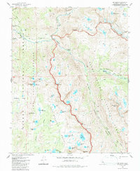
1983 Map of Mt. Henry
USGS Topo · Published 1987About this map
The South Fork San Joaquin River winds through the high Sierra Nevada landscape of Fresno County, forming a deep central drainage flanked by the John Muir Wilderness and Kings Canyon National Park. This 1983 survey records a pristine wilderness environment where the John Muir Trail and Pacific Crest National Scenic Trail intersect, highlighting the region's importance to early 20th-century conservation and mountaineering. The presence of the John Muir Trail Cabin and named sites like Reddys Hole indicate the light but permanent mark of trail development in these high elevations. Moving south from Pavilion Dome toward the Red Mountain Basin, the map details a complex glacial geography characterized by the Matthes Glaciers and high-altitude crossings such as Hell for Sure Pass and Mosquito Pass.
Find a feature on this map
59 named features on this map. Tap any name to fly to it.
Don’t see what you’re looking for? This feature index may not catch every label — zoom into the map to look around manually.
Map Details
Editions of this 1983 Mt. Henry Map
4 editions found
Other maps of this area

1912 · Mt. Goddard
USGS Topo · 1:125,000

1947 · Mariposa
USGS Topo · 1:250,000

1948 · Mariposa
USGS Topo · 1:250,000

1948 · Mt. Goddard
USGS Topo · 1:62,500

1949 · Mt. Tom
USGS Topo · 1:62,500

1951 · Mt. Tom
USGS Topo · 1:62,500

1951 · Mt. Goddard
USGS Topo · 1:62,500

1952 · Mt. Goddard
USGS Topo · 1:62,500

1953 · Mt Abbot
USGS Topo · 1:62,500

1953 · Blackcap Mtn
USGS Topo · 1:62,500