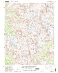
1982 Map of Mt. Hilgard
USGS Topo · Published 1994About this map
Lake Italy sits at the heart of this high-altitude landscape, surrounded by a dense concentration of glacial basins and granite summits within the Sierra National Forest. The map detail captures the remote character of the John Muir Wilderness during the early 1980s, documenting a network of trails including the Pacific Crest National Scenic Trail as it traverses the divide between Fresno and Inyo counties. The terrain is defined by dramatic elevation changes, from the depths of Piute Canyon and French Canyon to the sharp peaks of Bear Creek Spire and Mount Julius Caesar. A whimsical naming convention is evident in the lake clusters near Mt Hilgard, with Teddy Bear Lake, Brown Bear Lake, and Beartrap Lake grouped together. This survey provides essential data for researchers tracing the historical placement of high-country routes such as Italy Pass and Selden Pass.
Find a feature on this map
86 named features on this map. Tap any name to fly to it.
Don’t see what you’re looking for? This feature index may not catch every label — zoom into the map to look around manually.
Map Details
Editions of this 1982 Mt. Hilgard Map
4 editions found
Other maps of this area

1912 · Mt. Goddard
USGS Topo · 1:125,000

1947 · Mariposa
USGS Topo · 1:250,000

1948 · Mariposa
USGS Topo · 1:250,000

1948 · Mt. Goddard
USGS Topo · 1:62,500

1949 · Mt. Tom
USGS Topo · 1:62,500

1951 · Mt. Tom
USGS Topo · 1:62,500

1951 · Mt. Goddard
USGS Topo · 1:62,500

1952 · Mt. Goddard
USGS Topo · 1:62,500

1953 · Mt Abbot
USGS Topo · 1:62,500

1953 · Blackcap Mtn
USGS Topo · 1:62,500