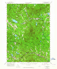
1956 Map of Mt. Kearsarge
USGS Topo · Published 1964About this map
Mt Kearsarge State Park dominates the center of this landscape, surrounded by a dense network of hill-country settlements in Merrimack County. The Boston and Maine railroad tracks weave through the valley north of the mountain, serving communities like Potter Place and Cilleyville. In the west, the campus of Colby Jr College is established near New London, while the southern reaches follow the Warner River through Warner and Lower Village. The map reveals a transition from the agricultural and mill past to a mid-century recreation economy, noted by the Kearsarge Valley Golf Course and several state forests. Water bodies such as Kezar Lake, Blaisdell Lake, and Bradley Lake are well-defined, serving as anchors for local recreation and historical industrial sites like Melvin Mills and Newmarket.
Find a feature on this map
143 named features on this map. Tap any name to fly to it.
Don’t see what you’re looking for? This feature index may not catch every label — zoom into the map to look around manually.
Map Details
Editions of this 1956 Mt. Kearsarge Map
4 editions found

Other maps of this area

1902 · Sunapee
USGS Topo · 1:62,500

1905 · Sunapee
USGS Topo · 1:62,500

1907 · Sunapee
USGS Topo · 1:62,500

1925 · Holderness
USGS Topo · 1:62,500

1926 · Hillsboro
USGS Topo · 1:62,500

1927 · Concord
USGS Topo · 1:62,500

1927 · Penacook
USGS Topo · 1:62,500

1927 · Holderness
USGS Topo · 1:62,500

1927 · Cardigan
USGS Topo · 1:62,500

1927 · Mascoma
USGS Topo · 1:62,500