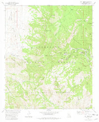
1981 Map of Mt. Lemmon
USGS Topo · Published 1981About this map
Summerhaven and the surrounding high peaks of the Santa Catalina Mountains are captured in this 1981 survey, reflecting a landscape defined by seasonal retreat and scientific installation. At the summit of Mt Lemmon, the map identifies an Observatory, Radio Towers, and a Heliport, highlighting the peak's importance for observation and communication. The settlement at Loma Linda and the nearby Catalina Camp show the concentrated development along the Mt Lemmon Highway, while the remainder of the terrain is dedicated to the Coronado National Forest and the Pusch Ridge Wilderness. Information-gain for researchers is found in the specific naming of dozens of remote water sources like Wooden Trough Spring and Flicker Spring, alongside legacy mining sites such as the Hartman Homestake Mines on the eastern slopes of Oracle Ridge.
Find a feature on this map
75 named features on this map. Tap any name to fly to it.
Don’t see what you’re looking for? This feature index may not catch every label — zoom into the map to look around manually.
Map Details
Editions of this 1981 Mt. Lemmon Map
3 editions found
Other maps of this area

1904 · Tucson
USGS Topo · 1:125,000

1905 · Tucson
USGS Topo · 1:125,000

1911 · Winkelman
USGS Topo · 1:125,000

1913 · Winkelman
USGS Topo · 1:125,000

1948 · Mammoth
USGS Topo · 1:62,500

1948 · Campo Bonito
USGS Topo · 1:24,000

1949 · Campo Bonito
USGS Topo · 1:24,000
1951 · Mammoth
USGS Topo · 1:62,500

1956 · Tucson
USGS Topo · 1:250,000

1957 · Bellota Ranch
USGS Topo · 1:62,500