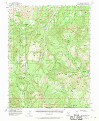
1954 Map of Mt Linnaeus
USGS Topo · Published 1970About this map
Cliff Dwellings and the ancient rock art of Newspaper Rock distinguish this high-desert plateau within the Manti-La Sal National Forest. Grounded by the 1952 aerial survey, the landscape shows a delicate balance between nomadic ranching outposts like Wilson Ranch and Kelly Ranch and the expansive protection of The Wilderness. This map reflects the mid-century's growing interest in the region's geological and archaeological heritage, documented here with cooperation from the Atomic Energy Commission. Cultural remnants appear throughout the canyon systems, from unidentified Ruins to isolated shelters like Duckett Cabin. Travel across the high ground is marked by the Angel Trail and several Jeep Trail routes, providing access to prominent overlooks including Maverick Point and Starvation Point. Notable landforms such as Cathedral Butte and the Seven Sisters Buttes dominate the skyline above complex drainages like Cottonwood Creek and Trough Canyon.
Find a feature on this map
76 named features on this map. Tap any name to fly to it.
Don’t see what you’re looking for? This feature index may not catch every label — zoom into the map to look around manually.
Map Details
Editions of this 1954 Mt Linnaeus Map
4 editions found
Other maps of this area

1885 · La Sal
USGS Topo · 1:250,000

1886 · Abajo
USGS Topo · 1:250,000

1892 · Abajo
USGS Topo · 1:250,000

1893 · Abajo
USGS Topo · 1:250,000

1935 · Elk Ridge
USGS Topo · 1:96,000

1940 · Elk Ridge
USGS Topo · 1:125,000

1953 · The Needles
USGS Topo · 1:62,500

1954 · Elk Ridge 4 NW
USGS Topo · 1:24,000

1954 · Elk Ridge 1 SW
USGS Topo · 1:24,000

1954 · Elk Ridge 2 SE
USGS Topo · 1:24,000