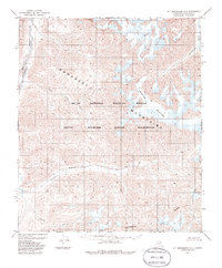
1983 Map of Mt. Michelson A-1
USGS Topo · Published 1986About this map
The Romanzof Mountains dominate this high-latitude terrain within the Arctic National Wildlife Refuge, where the topographic relief is defined by sharp peaks and active glacial systems. At the time of this 1980s study, the Okpilak Glacier descends through the eastern portion of the quadrangle, feeding the Okpilak River as it flows north toward the Beaufort Sea. The landscape serves as a critical hydrological transition point, marked by the Continental Divide cutting across the southern reaches of the map. North of this line, waters like the Hulahula River and East Fork Paluk Creek drain toward the Arctic Ocean, while the Sheenjek River represents the southern-flowing drainage system. This survey of the Arctic Wildlife Refuge Wilderness illustrates a roadless environment shaped entirely by tectonic uplift and ice.
Find a feature on this map
11 named features on this map. Tap any name to fly to it.
Don’t see what you’re looking for? This feature index may not catch every label — zoom into the map to look around manually.
Map Details
Editions of this 1983 Mt. Michelson A-1 Map
2 editions found
Other maps of this area

1951 · Demarcation Point
USGS Topo · 1:250,000

1951 · Arctic
USGS Topo · 1:250,000

1951 · Table Mountain
USGS Topo · 1:250,000

1951 · Mt. Michelson
USGS Topo · 1:250,000

1955 · Demarcation Point
USGS Topo · 1:250,000

1955 · Mount Michelson B-1
USGS Topo · 1:63,360

1956 · Table Mountain
USGS Topo · 1:250,000

1956 · Arctic
USGS Topo · 1:250,000

1956 · Mt. Michelson
USGS Topo · 1:250,000

1956 · Demarcation Point B-5
USGS Topo · 1:63,360