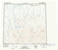
1951 Map of Mt. Michelson
USGS Topo · Published 1952About this map
Mt Michelson and Mt Chamberlin anchor the high peaks of the Brooks Range in this mid-century reconnaissance of the Arctic coast. The landscape is defined by the massive drainage systems of the Canning River and Hulahula River, which flow north from the Franklin Mountains and Romanzof Mountains toward the Beaufort Sea. Human presence is sparse, noted only by the isolated VABM 25 Cabin near Camden Bay and Simpson Cove. The map detail captures the glacial geography of Lake Schrader and Lake Peters, along with prominent landmarks like Kingak Cliff and Shubelik Spring. This era of mapping was heavily reliant on photogrammetric methods to chart the Sadlerochit Mountains and the surrounding wilderness before modern infrastructure arrived in the North Slope region.
Find a feature on this map
38 named features on this map. Tap any name to fly to it.
Don’t see what you’re looking for? This feature index may not catch every label — zoom into the map to look around manually.
Map Details
Editions of this 1951 Mt. Michelson Map
4 editions found
Other maps of this area

1951 · Beechey Point
USGS Topo · 1:250,000

1951 · Barter Island
USGS Topo · 1:250,000

1951 · Sagavanirktok D-5
USGS Topo · 1:250,000

1951 · Demarcation Point
USGS Topo · 1:250,000

1951 · Brooks
USGS Topo · 1:250,000

1951 · Arctic
USGS Topo · 1:250,000

1951 · Table Mountain
USGS Topo · 1:250,000

1951 · Mt. Michelson
USGS Topo · 1:250,000

1955 · Flaxman Island
USGS Topo · 1:250,000

1955 · Demarcation Point
USGS Topo · 1:250,000