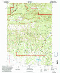
1992 Map of Mt. Pisgah
USGS Topo · Published 1997About this map
Ochocco National Forest dominates this landscape along the border of Wheeler and Crook counties, characterized by a complex network of springs and creek drainages. The northern portion is defined by the Bridge Creek Wilderness, where terrain rises toward prominent elevations like North Point and Mt Pisgah Lookout. This high country serves as a vital watershed, feeding numerous named water sources such as Maxwell Spring, Pisgah Spring, and Milk Spring.
Find a feature on this map
47 named features on this map. Tap any name to fly to it.
Don’t see what you’re looking for? This feature index may not catch every label — zoom into the map to look around manually.
Map Details
Editions of this 1992 Mt. Pisgah Map
This is the sole edition of this map. No revisions or reprints were ever made.
Other maps of this area

1926 · Mitchell
USGS Topo · 1:125,000

1951 · Lookout Mtn
USGS Topo · 1:62,500

1955 · Bend
USGS Topo · 1:250,000

1957 · Bend
USGS Topo · 1:250,000

1958 · Bend
USGS Topo · 1:250,000

1965 · Williams Prairie
USGS Topo · 1:24,000

1966 · Keys Creek
USGS Topo · 1:24,000

1966 · Peterson Point
USGS Topo · 1:24,000

1966 · Mt. Pisgah
USGS Topo · 1:24,000

1966 · Mitchell
USGS Topo · 1:62,500