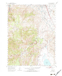
1950 Map of Mt. Rose
USGS Topo · Published 1984About this map
Bowers Mansion and the historic Ophir Mill Site sit at the eastern base of the Carson Range, overlooking the wide expanse of the Washoe Valley. This 1950 field-checked survey documents a transitional era where traditional agricultural and ranching landscapes met the early expansion of the Reno city limits and the Reno Airport. The map highlights the concentration of early settlement life through several educational landmarks, including Home Gardens School and Huffacker Lane Sch.
Find a feature on this map
71 named features on this map. Tap any name to fly to it.
Don’t see what you’re looking for? This feature index may not catch every label — zoom into the map to look around manually.
Map Details
Editions of this 1950 Mt. Rose Map

Other maps of this area

1890 · Sierraville
USGS Topo · 1:125,000

1891 · Carson
USGS Topo · 1:125,000

1891 · Truckee
USGS Topo · 1:125,000

1891 · Reno
USGS Topo · 1:125,000

1892 · Sierraville
USGS Topo · 1:125,000

1893 · Carson
USGS Topo · 1:125,000

1893 · Truckee
USGS Topo · 1:125,000

1893 · Reno
USGS Topo · 1:125,000

1894 · Sierraville
USGS Topo · 1:125,000

1895 · Truckee
USGS Topo · 1:125,000