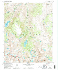
1983 Map of Mt. Thompson
USGS Topo · Published 1994About this map
Aspendell sits at the northern edge of this high-altitude landscape, serving as a gateway for the recreation and resource extraction that defined the region in the late 20th century. The high basins of the Inyo National Forest are dominated by glacial lakes and towering peaks, with significant water bodies like Lake Sabrina and South Lake serving as landmarks within the John Muir Wilderness. The eastern slopes show evidence of mining history through sites such as the Schober Mine and Salty Peterson Mine, alongside several mineral prospects. This map details the intersection of the Inyo Co and Fresno Co line, where the crest of the Sierra Nevada separates the forest from Kings Canyon National Park. The concentration of campgrounds, including Bishop Park Campground and Four Jeffrey Campground, illustrates the area's transition into a major center for mountain tourism and backcountry exploration.
Find a feature on this map
83 named features on this map. Tap any name to fly to it.
Don’t see what you’re looking for? This feature index may not catch every label — zoom into the map to look around manually.
Map Details
Editions of this 1983 Mt. Thompson Map
4 editions found
Other maps of this area

1912 · Mt. Goddard
USGS Topo · 1:125,000

1913 · Bishop
USGS Topo · 1:125,000

1947 · Mariposa
USGS Topo · 1:250,000

1948 · Mariposa
USGS Topo · 1:250,000

1948 · Mt. Goddard
USGS Topo · 1:62,500

1949 · Mt. Tom
USGS Topo · 1:62,500

1949 · Bishop
USGS Topo · 1:62,500

1950 · Big Pine
USGS Topo · 1:62,500

1951 · Mt. Tom
USGS Topo · 1:62,500

1951 · Mt. Goddard
USGS Topo · 1:62,500