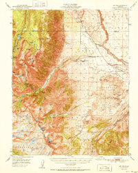
1951 Map of Mt. Tom
USGS Topo · Published 1951About this map
High-altitude extraction and technical surveying define this mid-century study of the Eastern Sierra. The map centers on the massive massif of Mt Tom, where a concentration of strategic mineral sites like the Tungstar Mine and Hanging Valley Mine cling to steep ridges. Lower in the drainage, the company settlement of Scheelite and the Vanadium Mine reflect the era's intensive industrial activity. These operations are contrasted by the presence of Petroglyphs near the Owens River Gorge, marking a much older human layer on the landscape.
Find a feature on this map
85 named features on this map. Tap any name to fly to it.
Don’t see what you’re looking for? This feature index may not catch every label — zoom into the map to look around manually.
Map Details
Editions of this 1951 Mt. Tom Map
2 editions found

Other maps of this area

1912 · Mt. Goddard
USGS Topo · 1:125,000

1913 · Bishop
USGS Topo · 1:125,000

1914 · Mt. Morrison
USGS Topo · 1:125,000

1917 · White Mountain
USGS Topo · 1:125,000

1947 · Mariposa
USGS Topo · 1:250,000

1948 · Mariposa
USGS Topo · 1:250,000

1948 · Mt. Goddard
USGS Topo · 1:62,500

1949 · Mt. Tom
USGS Topo · 1:62,500

1949 · Bishop
USGS Topo · 1:62,500

1950 · Big Pine
USGS Topo · 1:62,500