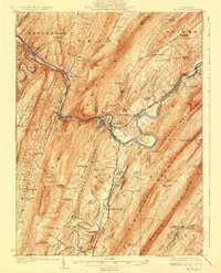
1924 Map of Mt. Union
USGS Topo · Published 1924About this map
The Juniata River winds through a landscape defined by sharp ridges and deep valleys, anchored by the industrial and transport hub at Mount Union. This 1920s topography highlights a region dependent on the Pennsylvania Railroad, which follows the river's path past Mapleton Depot and Newton Hamilton. The map reveals a dense network of early 20th-century rural infrastructure, including a remarkable concentration of one-room schoolhouses such as Lucy Furnace School, Corbin School, and Ross Grove School that served the isolated valley communities between Jacks Mountain and Blue Mountain. Local industry and commerce are reflected in places like Atkinson Mills and the Pump Station along Aughwick Creek. In the south, the village of Shirleysburg and the Richvale Shade Valley PO mark long-established settlements situated along early state highways and mountain gaps.
Find a feature on this map
111 named features on this map. Tap any name to fly to it.
Don’t see what you’re looking for? This feature index may not catch every label — zoom into the map to look around manually.
Map Details
Editions of this 1924 Mt. Union Map
4 editions found
Other maps of this area

1901 · Huntingdon
USGS Topo · 1:62,500

1904 · Huntingdon
USGS Topo · 1:62,500

1919 · Mattawana
USGS Topo · 1:62,500

1919 · Menno
USGS Topo · 1:62,500

1922 · Mt Union
USGS Topo · 1:48,000

1923 · Shippensburg
USGS Topo · 1:62,500

1923 · Tyrone
USGS Topo · 1:62,500

1924 · Mt. Union
USGS Topo · 1:62,500

1924 · Lewistown
USGS Topo · 1:62,500

1927 · Lewisburg
USGS Topo · 1:62,500