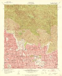
1953 Map of Mt. Wilson
USGS Topo · Published 1955About this map
The San Gabriel Mountains dominate the northern half of this mid-century survey, where a network of trails and camps like Sturtevant Camp and Orchard Camp indicates the region's established role as a recreational escape for the Los Angeles basin. In the foothills, the transition from wild terrain to suburban expansion is evident in the dense residential grids of Altadena, Pasadena, and Sierra Madre. Notable institutions such as the Calif Institute of Technology and Pasadena City College are clearly defined, while the cultural influence of the era is marked by the Huntington Art Gallery in San Marino. A historical layer of transportation is preserved here as well, showing the PE Electric RR and the Echo Mountain (Site), reflecting the legacy of the Mount Lowe Railway. High above, the observatory and Mt Wilson P O anchor the peak that served as a critical scientific and communications hub for Southern California.
Find a feature on this map
99 named features on this map. Tap any name to fly to it.
Don’t see what you’re looking for? This feature index may not catch every label — zoom into the map to look around manually.
Map Details
Editions of this 1953 Mt. Wilson Map
3 editions found
Other maps of this area

1894 · Los Angeles
USGS Topo · 1:62,500

1894 · Pomona
USGS Topo · 1:62,500

1896 · Pasadena
USGS Topo · 1:62,500

1897 · Pomona
USGS Topo · 1:62,500

1898 · Pomona
USGS Topo · 1:62,500

1900 · Pasadena
USGS Topo · 1:62,500

1900 · Tujunga
USGS Topo · 1:62,500

1900 · Los Angeles
USGS Topo · 1:62,500

1901 · Southern California Sheet No. 1
USGS Topo · 1:250,000

1903 · Rock Creek
USGS Topo · 1:62,500