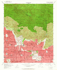
1953 Map of Mt. Wilson
USGS Topo · Published 1964About this map
The San Gabriel Mountains rise sharply above the expanding urban landscape of the San Gabriel Valley, where the postwar growth of Pasadena, Altadena, and Sierra Madre meets the National Forest Boundary. This era of the early 1950s captures the transition of the mountain front from a resort destination to a communications hub, with TV Transmitters and an Observatory crowning Mt Wilson while the footprints of the Great Lowe Canyon Railway era remain at Mt Lowe (Site) and Echo Mountain (Site). Below the peaks, the residential grid is punctuated by major institutions like the Calif Institute of Technology and the Huntington Art Gallery in San Marino. The map records an intricate network of hiking camps such as Idlehour Camp and Sturtevant Camp, alongside the early water management infrastructure of the Santa Anita Dam and Eaton Wash flood control systems.
Find a feature on this map
97 named features on this map. Tap any name to fly to it.
Don’t see what you’re looking for? This feature index may not catch every label — zoom into the map to look around manually.
Map Details
Editions of this 1953 Mt. Wilson Map
3 editions found
Other maps of this area

1894 · Los Angeles
USGS Topo · 1:62,500

1894 · Pomona
USGS Topo · 1:62,500

1896 · Pasadena
USGS Topo · 1:62,500

1897 · Pomona
USGS Topo · 1:62,500

1898 · Pomona
USGS Topo · 1:62,500

1900 · Pasadena
USGS Topo · 1:62,500

1900 · Tujunga
USGS Topo · 1:62,500

1900 · Los Angeles
USGS Topo · 1:62,500

1901 · Southern California Sheet No. 1
USGS Topo · 1:250,000

1903 · Rock Creek
USGS Topo · 1:62,500