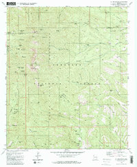
1981 Map of Mt. Wrightson
USGS Topo · Published 1981About this map
The high ridges of the Santa Rita Mountains dominate this 1981 survey of the Arizona backcountry, centered on the dramatic elevation of Mt Wrightson and Josephine Peak. Within the Coronado National Forest, the landscape reveals a dense history of resource extraction, with numerous workings such as the Lucky Ledge Mine, Silver King Mine, and the East Compadre Shaft peppering the canyons. The topography is defined by steep drainages like Florida Canyon and Josephine Canyon, which served as vital corridors for both early mining and later recreation.
Find a feature on this map
83 named features on this map. Tap any name to fly to it.
Don’t see what you’re looking for? This feature index may not catch every label — zoom into the map to look around manually.
Map Details
Editions of this 1981 Mt. Wrightson Map
2 editions found
Other maps of this area

1904 · Patagonia
USGS Topo · 1:125,000

1905 · Patagonia
USGS Topo · 1:125,000

1922 · Agus Caliente
USGS Topo · 1:62,500

1926 · Helvetia
USGS Topo · 1:62,500

1932 · Elgin
USGS Topo · 1:62,500

1940 · Elgin
USGS Topo · 1:62,500

1947 · Elgin
USGS Topo · 1:62,500

1948 · Sonoita
USGS Topo · 1:24,000
1948 · Mt. Hughes
USGS Topo · 1:24,000

1956 · Nogales
USGS Topo · 1:250,000