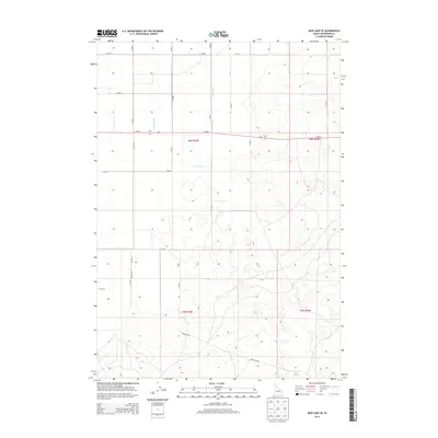
2013 Map of Mud Lake SE
USGS Topo · Published 2013About this map
Holly Canal and Jackett Canal define the irrigation landscape of this eastern Idaho territory, illustrating the intensive management of water resources required for agriculture in Jefferson County. The terrain is organized by an exacting grid of rural roads, including Bott Rd and Roberts Rd, which divide the high desert into predictable parcels. This 2013 survey shows the intersection of several township boundaries, notably where t6n r35e and t6n r36e meet, marking the organized expansion of settlement. While largely defined by these straight-line transport corridors like E 1500 N and Mud Lake Rd, the map also preserves the natural undulations of the landscape between the man-made canals and primary thoroughfares such as N 1825 E.
Find a feature on this map
21 named features on this map. Tap any name to fly to it.
Don’t see what you’re looking for? This feature index may not catch every label — zoom into the map to look around manually.
Map Details
Editions of this 2013 Mud Lake SE Map
This is the sole edition of this map. No revisions or reprints were ever made.
Other maps of this area

1949 · Roberts
USGS Topo · 1:62,500

1949 · Roberts
USGS Topo · 1:24,000

1950 · Roberts
USGS Topo · 1:24,000

1955 · Idaho Falls
USGS Topo · 1:250,000

1958 · Idaho Falls
USGS Topo · 1:250,000

1964 · Kettle Butte NE
USGS Topo · 1:24,000

1964 · Kettle Butte NW
USGS Topo · 1:24,000

1964 · Terreton
USGS Topo · 1:24,000
1964 · Market Lake
USGS Topo · 1:24,000

1964 · Mud Lake SE
USGS Topo · 1:24,000