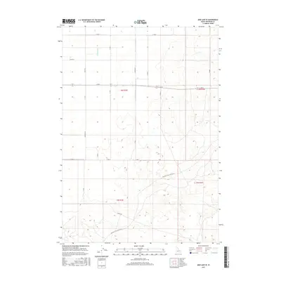
2017 Map of Mud Lake SE
USGS Topo · Published 2017About this map
Holly Canal and Jackett Canal cut through this southeastern corner of the Mud Lake basin, illustrating the critical role of water management in the high desert of Jefferson County. The landscape is defined by a strictly organized grid of agricultural roads and irrigation infrastructure, reflecting the modern evolution of the Snake River Plain's reclamation projects. Significant transportation corridors, such as Twin Butte Sage Junction Rd and Roberts Rd, anchor the southern half of the map, while the northern sections are divided by family-named routes like Koefoed Rd and Linderman Rd. The terrain remains largely open, characterized by subtle elevation changes and the distinctive section-line patterns of the Public Land Survey System that have dictated settlement and land use in this part of Idaho for generations.
Find a feature on this map
24 named features on this map. Tap any name to fly to it.
Don’t see what you’re looking for? This feature index may not catch every label — zoom into the map to look around manually.
Map Details
Editions of this 2017 Mud Lake SE Map
This is the sole edition of this map. No revisions or reprints were ever made.
Other maps of this area

1949 · Roberts
USGS Topo · 1:62,500

1949 · Roberts
USGS Topo · 1:24,000

1950 · Roberts
USGS Topo · 1:24,000

1955 · Idaho Falls
USGS Topo · 1:250,000

1958 · Idaho Falls
USGS Topo · 1:250,000

1964 · Kettle Butte NE
USGS Topo · 1:24,000

1964 · Kettle Butte NW
USGS Topo · 1:24,000

1964 · Terreton
USGS Topo · 1:24,000
1964 · Market Lake
USGS Topo · 1:24,000

1964 · Mud Lake SE
USGS Topo · 1:24,000