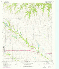
1961 Map of Muenster East
USGS Topo · Published 1978About this map
Muenster and Myra anchor the southwestern corner of this landscape, positioned along a transportation corridor marked by an Old Railroad Grade and Railroad Grade. The terrain is defined by the prominent Wolf Ridge, which separates the northern drainages like Opossum Hollow and Black Hollow from the complex creek systems to the south. Dry Elm Creek and its tributaries, including Squirrel Creek and Tonkawa Creek, create a deeply dissected landscape of draws and ridges. Local history is preserved in family-named sites such as Hayes Cem and Van Slyke Cem, while the industrial footprint of the mid-20th century is seen in several Gravel Pits and a modern Filtration Plant. To the northeast, the corner of Moss Lake provides a contrast to the seasonal flows of the dry elm branches that dominate the central map area.
Find a feature on this map
23 named features on this map. Tap any name to fly to it.
Don’t see what you’re looking for? This feature index may not catch every label — zoom into the map to look around manually.
Map Details
Editions of this 1961 Muenster East Map
2 editions found
Other maps of this area

1902 · Gainesville
USGS Topo · 1:125,000

1943 · Gainesville
USGS Topo · 1:125,000

1954 · Sherman
USGS Topo · 1:250,000

1958 · Sherman
USGS Topo · 1:250,000

1960 · Gainesville South
USGS Topo · 1:24,000

1960 · Gainesville North
USGS Topo · 1:24,000

1961 · Muenster West
USGS Topo · 1:24,000

1961 · Freemound
USGS Topo · 1:24,000

1961 · Hood
USGS Topo · 1:24,000

1961 · Muenster East
USGS Topo · 1:24,000