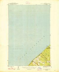
1948 Map of Muggun Creek
USGS Topo · Published 1948About this map
Lake Superior dominates this mid-century survey, its coastline forming a sharp diagonal across the northwestern Keweenaw Peninsula. The interior landscape is defined by the boundary between Keweenaw County and Houghton County, where the terrain rises toward the rugged elevations of the Copper Country. This map documents critical infrastructure supporting the region's industrial and municipal needs, specifically identifying the Tamarack Waterworks and Calumet Waterworks positioned near the shoreline. Small coastal drainages like Muggun Creek and Gardeners Creek cut through the topography toward the lake, while the outskirts of Allouez and Calumet appear in the southern and eastern corners. The layout reflects a landscape dedicated to utility and mining-era settlement, captured just after the Second World War.
Find a feature on this map
8 named features on this map. Tap any name to fly to it.
Don’t see what you’re looking for? This feature index may not catch every label — zoom into the map to look around manually.
Map Details
Editions of this 1948 Muggun Creek Map
2 editions found
Other maps of this area

1915 · Houghton
USGS Topo · 1:62,500

1941 · Ahmeek
USGS Topo · 1:31,680

1946 · Hancock
USGS Topo · 1:24,000

1946 · Muggun Creek
USGS Topo · 1:24,000

1946 · Ahmeek
USGS Topo · 1:24,000

1946 · Laurium
USGS Topo · 1:24,000

1947 · Ahmeek
USGS Topo · 1:24,000
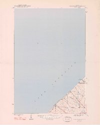
1948 · Muggun Creek
USGS Topo · 1:24,000

1948 · Laurium
USGS Topo · 1:24,000

1948 · Hancock
USGS Topo · 1:24,000