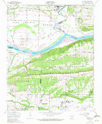
1948 Map of Mulberry
USGS Topo · Published 1972About this map
Mulberry serves as the focal point for this survey of the Arkansas river valley, situated where the Missouri Pacific railroad skirts the bottomlands of the Mulberry River. The landscape is a complex arrangement of alluvial flats like Vine Prairie and Maxey, interrupted by the prominent ridge of Mill Creek Mountain. To the south, the recently developed Ozark Reservoir has altered the traditional flow of the Arkansas River, inundating old sloughs while leaving landmarks like Arbuckle Island and the Courthouse Slough as evidence of the river's former path.
Find a feature on this map
45 named features on this map. Tap any name to fly to it.
Don’t see what you’re looking for? This feature index may not catch every label — zoom into the map to look around manually.
Map Details
Editions of this 1948 Mulberry Map
4 editions found
Other maps of this area

1879 · Cravens
USGS Topo · 1:62,500

1887 · Magazine Mountain #2
USGS Topo · 1:62,500

1887 · Watalula
USGS Topo · 1:62,500

1887 · Magazine Mountain
USGS Topo · 1:62,500

1890 · Magazine Mountain
USGS Topo · 1:125,000

1890 · Fort Smith
USGS Topo · 1:125,000

1898 · Winslow #4
USGS Topo · 1:62,500

1898 · Winslow
USGS Topo · 1:125,000

1901 · Winslow
USGS Topo · 1:125,000

1906 · Lavaca
USGS Topo · 1:62,500