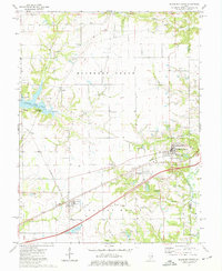
1974 Map of Mulberry Grove
USGS Topo · Published 1977About this map
Mulberry Grove and Smithboro anchor this Bond County landscape during a period of infrastructure growth and recreational development. The arrival of Interstate 70 cuts a modern path across the southern half of the quadrangle, running parallel to the established Penn Central rail line. To the west, the expansion of Governor Bond Lake has transformed the terrain near Woburn and Durley, supporting seasonal escapes like Camp Shadyjack and Durley Camp. Local history is deeply embedded in the rural sections of Mulberry Grove and Pleasant Mound townships, where numerous family and community burial grounds such as Hastings Cem, Etcheson Cem, and Seagraves Cem remain preserved. The drainage patterns of Hurricane Cr and Kingsbury Branch define the timbered breaks between the sprawling agricultural fields of mid-1970s Illinois.
Find a feature on this map
32 named features on this map. Tap any name to fly to it.
Don’t see what you’re looking for? This feature index may not catch every label — zoom into the map to look around manually.
Map Details
Editions of this 1974 Mulberry Grove Map
2 editions found
Other maps of this area

1932 · Greenville
USGS Topo · 1:62,500

1939 · Greenville
USGS Topo · 1:62,500

1943 · Greenville
USGS Topo · 1:62,500

1944 · Ramsey
USGS Topo · 1:62,500

1945 · Vandalia
USGS Topo · 1:62,500

1946 · Ramsey
USGS Topo · 1:62,500

1947 · Vandalia
USGS Topo · 1:62,500

1947 · Hillsboro
USGS Topo · 1:62,500

1949 · Hillsboro
USGS Topo · 1:62,500

1958 · Decatur
USGS Topo · 1:250,000