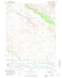
1951 Map of Mule Butte
USGS Topo · Published 1976About this map
The Wind River Indian Reservation landscape is defined by the complex hydraulic engineering of the Riverton Reclamation Project and the winding confluence of the Wind River and Little Wind River. This 1951 survey documents the intricate network of the Le Clair Canal, Blackburn Ditch, and Hansen Drain as they traverse the Johnstown Valley and Riverview Valley. The interaction between these irrigation systems and the natural terrain around Mule Butte and the Red Buttes illustrates the mid-century effort to transform this arid Wyoming basin into productive agricultural land. Local history is anchored by the Shakespeare Cem and St Michael, providing specific points of interest for genealogists tracing early families in this part of Fremont County near the Wind River Base Line.
Find a feature on this map
19 named features on this map. Tap any name to fly to it.
Don’t see what you’re looking for? This feature index may not catch every label — zoom into the map to look around manually.
Map Details
Editions of this 1951 Mule Butte Map
4 editions found
Other maps of this area

1950 · Pavillion
USGS Topo · 1:24,000

1950 · Ocean Lake
USGS Topo · 1:24,000

1951 · Mule Butte
USGS Topo · 1:24,000

1951 · Pavillion SE
USGS Topo · 1:24,000

1951 · Morton
USGS Topo · 1:24,000

1951 · Ethete
USGS Topo · 1:24,000

1952 · Hudson
USGS Topo · 1:24,000

1952 · Ray Lake
USGS Topo · 1:24,000

1952 · Lander NW
USGS Topo · 1:24,000

1955 · Thermopolis
USGS Topo · 1:250,000