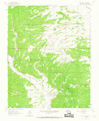
1963 Map of Mule Canyon
USGS Topo · Published 1967About this map
The Rio Tusas valley anchors this mid-century survey of the high country in Carson National Forest. The landscape is defined by the massive spine of Tusas Ridge and a complex network of drainage basins including American Creek and Cow Creek. Evidence of local ranching and water management is visible through numerous named catchments like Esquibel Tank, North Star Tank, and Kutch Tank, while Barela Spring and Raybals Spring provide natural water sources in the higher elevations. Genealogy researchers will find the Tusas Cem located along the river, a key marker of the families who settled this area of Rio Arriba. Small-scale resource extraction is indicated by Prospects in the northeast, showing the continued interest in the mineral potential of the Martinez Canyon and Esquibel Canyon vicinities.
Find a feature on this map
29 named features on this map. Tap any name to fly to it.
Don’t see what you’re looking for? This feature index may not catch every label — zoom into the map to look around manually.
Map Details
Editions of this 1963 Mule Canyon Map
2 editions found
Other maps of this area

1918 · Tusas
USGS Topo · 1:125,000

1954 · Raton
USGS Topo · 1:250,000

1954 · Aztec
USGS Topo · 1:250,000

1958 · Raton
USGS Topo · 1:250,000

1958 · Aztec
USGS Topo · 1:250,000

1962 · Aztec
USGS Topo · 1:250,000
1963 · Las Tablas
USGS Topo · 1:24,000

1963 · Broke Off Mountain
USGS Topo · 1:24,000

1963 · Burned Mountain
USGS Topo · 1:24,000
1963 · La Segita Peaks
USGS Topo · 1:24,000