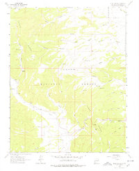
1963 Map of Mule Canyon
USGS Topo · Published 1978About this map
Carson National Forest dominates this high-altitude landscape of northern New Mexico, where the peaks of Tusas Ridge overlook a complex network of drainages and seasonal water sources. The mapping of this terrain in the early 1960s highlights the reliance on isolated water points such as Barela Spring, Biscara Spring, and Alex Tank for livestock and land management. The presence of the Tusas Cem and several Prospects suggests the legacy of small-scale settlement and mineral exploration near the Rio Tusas. The geography is defined by deep cuts like Mule Canyon and Martinez Canyon, which historically served as natural conduits through the timbered highlands. This survey documents the intersection of natural resources and early 20th-century land use, from the timbered slopes to the naming of family landmarks like Roybals Spring and Esquibel Canyon.
Find a feature on this map
35 named features on this map. Tap any name to fly to it.
Don’t see what you’re looking for? This feature index may not catch every label — zoom into the map to look around manually.
Map Details
Editions of this 1963 Mule Canyon Map
2 editions found
Other maps of this area

1918 · Tusas
USGS Topo · 1:125,000

1954 · Raton
USGS Topo · 1:250,000

1954 · Aztec
USGS Topo · 1:250,000

1958 · Raton
USGS Topo · 1:250,000

1958 · Aztec
USGS Topo · 1:250,000

1962 · Aztec
USGS Topo · 1:250,000
1963 · Las Tablas
USGS Topo · 1:24,000

1963 · Broke Off Mountain
USGS Topo · 1:24,000

1963 · Burned Mountain
USGS Topo · 1:24,000
1963 · La Segita Peaks
USGS Topo · 1:24,000