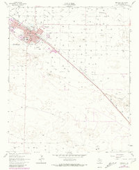
1962 Map of Muleshoe
USGS Topo · Published 1981About this map
Muleshoe is anchored by the diagonal corridor of the Panhandle and Santa Fe railroad, which defines the town’s layout and growth. The community serves as an educational and civic hub for this portion of Bailey County, featuring several named schools such as Richland Hills Sch, Hilltop Sch, and Mary Del Shazo Sch. The landscape is dominated by the broad, dry path of Blackwater Draw, with numerous wells and scattered depressions like Willow Lake indicating the area's reliance on groundwater for agriculture.
Find a feature on this map
36 named features on this map. Tap any name to fly to it.
Don’t see what you’re looking for? This feature index may not catch every label — zoom into the map to look around manually.
Map Details
Editions of this 1962 Muleshoe Map
2 editions found
Other maps of this area

1954 · Clovis
USGS Topo · 1:250,000

1958 · Clovis
USGS Topo · 1:250,000

1962 · Muleshoe
USGS Topo · 1:24,000

1962 · Needmore
USGS Topo · 1:24,000

1962 · Baileyboro NE
USGS Topo · 1:24,000

1962 · Baileyboro
USGS Topo · 1:24,000

1962 · Sudan
USGS Topo · 1:24,000

1962 · Muleshoe NE
USGS Topo · 1:24,000

1963 · Lazbuddie SW
USGS Topo · 1:24,000

1963 · Progress
USGS Topo · 1:24,000