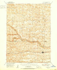
1951 Map of Mullen
USGS Topo · Published 1951About this map
The confluence of the Middle Loup River branches dominates this Nebraska Sandhills landscape, where the Chicago Burlington and Quincy railroad follows the valley floor. The village of Mullen sits as a primary rail point, with the smaller settlement of Hecla to the west. This mid-century survey illustrates a classic prairie settlement pattern, where the water resources of the North Branch, Middle Branch, and South Branch dictate the placement of roads and homesteads. Local education is represented by a series of rural schools distributed across the hills, including Prentice Sch, Cherry Sch, Delight Sch, Reigle Sch, Harding Sch, and Barnaby Sch. The map also captures the topography of Dry Valley and the flow of Calf Creek, providing a detailed view of Hooker and Cherry Counties before modern irrigation and interstate travel transformed the region.
Find a feature on this map
21 named features on this map. Tap any name to fly to it.
Don’t see what you’re looking for? This feature index may not catch every label — zoom into the map to look around manually.
Map Details
Editions of this 1951 Mullen Map
2 editions found

Other maps of this area

1947 · Dismal River Ranch
USGS Topo · 1:62,500

1948 · Seneca
USGS Topo · 1:62,500

1948 · Carr Lake
USGS Topo · 1:62,500

1948 · Mullen
USGS Topo · 1:62,500

1949 · Dismal River Ranch
USGS Topo · 1:62,500

1949 · Big Falls
USGS Topo · 1:62,500

1950 · Carr Lake
USGS Topo · 1:62,500

1950 · Hire
USGS Topo · 1:62,500

1950 · Shimmins Lake
USGS Topo · 1:62,500

1950 · Wolf Lake
USGS Topo · 1:62,500