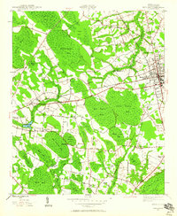
1946 Map of Mullins
USGS Topo · Published 1960About this map
Mullins and the surrounding coastal plain of Marion County are defined by a complex network of elliptical depressional wetlands known locally as bays. These features, including Maidendown Bay, Big Sister Bay, and the twin Little Horsepen Bay and Big Horsepen Bay, dominate the landscape between the Atlantic Coast Line and Seaboard Line railroads. The 1946 survey reveals a rural society structured around these natural boundaries, with small schools like Smith Swamp Sch and Todd Sch and numerous community landmarks such as Wise Chapel and Sandy Grove Ch dotting the crossroads. The concentration of family and community burial grounds, including Brown Cem, Smithy Cem, and Waldon Cem, offers significant detail for genealogical research into the area's mid-century residents. The drainage patterns of Maidendown Swamp and Smith Swamp illustrate how early agriculture and infrastructure navigated the saturated Carolina terrain.
Find a feature on this map
50 named features on this map. Tap any name to fly to it.
Don’t see what you’re looking for? This feature index may not catch every label — zoom into the map to look around manually.
Map Details
Editions of this 1946 Mullins Map
4 editions found
Other maps of this area

1943 · Pages Mill
USGS Topo · 1:62,500

1946 · Mullins
USGS Topo · 1:24,000

1947 · Friendship
USGS Topo · 1:24,000

1947 · Marion
USGS Topo · 1:24,000

1947 · Centenary
USGS Topo · 1:24,000

1947 · Mullins
USGS Topo · 1:24,000

1948 · Galivants Ferry
USGS Topo · 1:24,000

1948 · Nichols
USGS Topo · 1:24,000

1950 · Galivants Ferry
USGS Topo · 1:24,000

1950 · Nichols
USGS Topo · 1:24,000