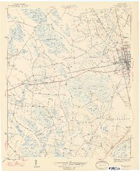
1947 Map of Mullins
USGS Topo · Published 1947About this map
Mullins and North Mullins anchor the eastern edge of this Marion County landscape, serving as a hub where the Seaboard Air Line and Atlantic Coast Line railroads intersect. The surrounding countryside is defined by an intricate network of Carolina bays—shallow, elliptical depressions such as Big Sister Bay, Maidendown Bay, and Tenmile Bay—that dictate the movement of local water through Smith Swamp and Back Swamp. This 1947 survey captures a rural social geography populated by numerous neighborhood institutions, including the Gapway Sch, Smith Swamp Sch, and Wise Chapel. For genealogists, the map is particularly valuable for its documentation of family-named sites and burial grounds like Smithy Cem, Waldon Cem, and Ammons Cem, many of which sit at the margins of the area's timbered wetlands and small agricultural clearings.
Find a feature on this map
48 named features on this map. Tap any name to fly to it.
Don’t see what you’re looking for? This feature index may not catch every label — zoom into the map to look around manually.
Map Details
Editions of this 1947 Mullins Map
2 editions found
Other maps of this area

1943 · Pages Mill
USGS Topo · 1:62,500

1946 · Mullins
USGS Topo · 1:24,000

1947 · Friendship
USGS Topo · 1:24,000

1947 · Marion
USGS Topo · 1:24,000

1947 · Centenary
USGS Topo · 1:24,000

1947 · Mullins
USGS Topo · 1:24,000

1948 · Galivants Ferry
USGS Topo · 1:24,000

1948 · Nichols
USGS Topo · 1:24,000

1950 · Galivants Ferry
USGS Topo · 1:24,000

1950 · Nichols
USGS Topo · 1:24,000