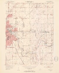
1952 Map of Muncie East
USGS Topo · Published 1953About this map
The White River anchors this 1952 study of Eastern Delaware County, flowing past the growing industrial and residential edges of Muncie. The eastern neighborhoods of Morning Side, Creston, and Mayfield show a post-war landscape in transition, where new residential streets meet established landmarks like the Delaware Country Club and the Wilbur E Sutton Sch. This era predates the large-scale highway expansions that would later reshape the region, preserving a view of the rail-centered economy driven by the New York Central and the Chesapeake and Ohio railroads.
Find a feature on this map
60 named features on this map. Tap any name to fly to it.
Don’t see what you’re looking for? This feature index may not catch every label — zoom into the map to look around manually.
Map Details
Editions of this 1952 Muncie East Map
2 editions found
Other maps of this area

1952 · Muncie East
USGS Topo · 1:24,000

1952 · Farmland
USGS Topo · 1:24,000

1952 · Muncie West
USGS Topo · 1:24,000

1953 · Muncie
USGS Topo · 1:250,000

1956 · Muncie
USGS Topo · 1:250,000

1960 · Eaton
USGS Topo · 1:24,000

1960 · Mount Pleasant
USGS Topo · 1:24,000

1960 · Wheeling
USGS Topo · 1:24,000

1960 · Sulphur Springs
USGS Topo · 1:24,000
1960 · Modoc
USGS Topo · 1:24,000