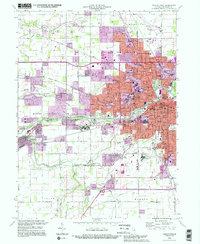
1992 Map of Muncie West
USGS Topo · Published 1995About this map
Ball State University and the expansive urban core of Muncie dominate this late-century landscape, capturing the city during a period of significant post-war modernization. The map documents the dense residential and educational infrastructure surrounding the university, including numerous neighborhood schools like Mitchell Sch and Northwest High Sch. Along the White River, the transition from the industrial and civic center of Muncie to the suburban growth of Yorktown and Andersonville is clearly defined. Genealogists will find considerable value in the detailed plotting of local burial grounds, ranging from the large Beech Grove Cemetery and Elm Ridge Memorial Park to smaller sites like Tomlinson Cem and Mt Zion Cem. Transport corridors are well-established, with the Conrail and Norfolk and Western RR lines intersecting the landscape alongside major arteries like Mc Galliard Rd.
Find a feature on this map
69 named features on this map. Tap any name to fly to it.
Don’t see what you’re looking for? This feature index may not catch every label — zoom into the map to look around manually.
Map Details
Editions of this 1992 Muncie West Map
2 editions found
Other maps of this area

1952 · Muncie East
USGS Topo · 1:24,000

1952 · Muncie West
USGS Topo · 1:24,000

1953 · Muncie
USGS Topo · 1:250,000

1956 · Muncie
USGS Topo · 1:250,000

1960 · Gilman
USGS Topo · 1:24,000

1960 · Middletown
USGS Topo · 1:24,000

1960 · Eaton
USGS Topo · 1:24,000

1960 · Mount Pleasant
USGS Topo · 1:24,000

1960 · Wheeling
USGS Topo · 1:24,000

1960 · Sulphur Springs
USGS Topo · 1:24,000