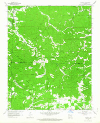
1957 Map of Mundell
USGS Topo · Published 1964About this map
Mundell and the winding course of the White River anchor this topographic study of the Ozark highlands at the junction of Carroll, Benton, and Madison counties. The landscape is defined by its deep, named hollows such as Hogscald Hollow, Penitentiary Hollow, and Durham Mill Hollow, which cut between prominent elevations like Swain Mountain and Grindstone Mountain. This late 1950s terrain shows a scattered rural settlement pattern connected by winding paths and unimproved dirt roads, centered around small community hubs and places of worship.
Find a feature on this map
46 named features on this map. Tap any name to fly to it.
Don’t see what you’re looking for? This feature index may not catch every label — zoom into the map to look around manually.
Map Details
Editions of this 1957 Mundell Map
Other maps of this area

1900 · Eureka Springs
USGS Topo · 1:125,000

1901 · Eureka Springs
USGS Topo · 1:125,000

1945 · Harrison
USGS Topo · 1:250,000

1949 · Harrison
USGS Topo · 1:250,000

1954 · Harrison
USGS Topo · 1:250,000

1957 · Mundell
USGS Topo · 1:24,000

1957 · War Eagle
USGS Topo · 1:24,000
1957 · Beaver
USGS Topo · 1:24,000
1958 · Spring Valley
USGS Topo · 1:24,000

1958 · Hindsville
USGS Topo · 1:24,000