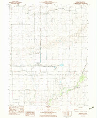
1982 Map of Murdock
USGS Topo · Published 1983About this map
The town of Murdock serves as a central hub in this corner of Douglas County, where the industrial presence of the Baltimore and Ohio railroad meets a landscape shaped by coal extraction. Evidence of the area's mining history is scattered throughout, notably at the Mine Shaft, Air Shaft, and several Mine Dump sites. To the north, the village of Fairland borders the Missouri Pacific rail line, illustrating the importance of these transport corridors to small-town Illinois development. Away from the tracks, the terrain is defined by the winding waters of the Slough and Jordan, while the southern reaches feature the Mayhall Landing Strip. Local heritage is anchored by longstanding institutions like Wesley Chapel and the Murdock Cem, Jordan Cem, and Albin Cem, which provide essential points of reference for genealogists tracking family ties in the Camargo and Bowdre townships.
Find a feature on this map
31 named features on this map. Tap any name to fly to it.
Don’t see what you’re looking for? This feature index may not catch every label — zoom into the map to look around manually.
Map Details
Editions of this 1982 Murdock Map
This is the sole edition of this map. No revisions or reprints were ever made.
Other maps of this area

1936 · Oakland
USGS Topo · 1:48,000

1942 · Oakland
USGS Topo · 1:62,500

1946 · Kansas
USGS Topo · 1:62,500

1949 · Kansas
USGS Topo · 1:62,500

1953 · Indianapolis
USGS Topo · 1:250,000

1956 · Indianapolis
USGS Topo · 1:250,000

1956 · Newman
USGS Topo · 1:62,500

1956 · Villa Grove
USGS Topo · 1:62,500

1957 · Indianapolis
USGS Topo · 1:250,000

1958 · Decatur
USGS Topo · 1:250,000