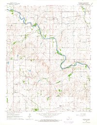
1965 Map of Murdock
USGS Topo · Published 1966About this map
The South Fork Winnescah River carves a winding path through the center of this landscape, anchoring a rural community defined by agricultural tradition and the mid-century energy economy. In Murdock, the Atchison Topeka and Santa Fe railroad serves the grain elevators and homesteads, while the southern settlement of Belmont is positioned along the Missouri Pacific line.
Find a feature on this map
22 named features on this map. Tap any name to fly to it.
Don’t see what you’re looking for? This feature index may not catch every label — zoom into the map to look around manually.
Map Details
Editions of this 1965 Murdock Map
This is the sole edition of this map. No revisions or reprints were ever made.
Other maps of this area

1889 · Anthony
USGS Topo · 1:125,000

1889 · Cheney
USGS Topo · 1:125,000

1889 · Caldwell
USGS Topo · 1:125,000

1891 · Cheney
USGS Topo · 1:125,000

1891 · Anthony
USGS Topo · 1:125,000

1892 · Kingman
USGS Topo · 1:125,000

1893 · Caldwell
USGS Topo · 1:125,000

1894 · Kingman
USGS Topo · 1:125,000

1897 · Caldwell
USGS Topo · 1:125,000

1901 · Cheney
USGS Topo · 1:125,000