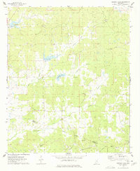
1975 Map of Murdock Lake
USGS Topo · Published 1978About this map
Abiaca Creek and its tributaries define the rolling landscape of this mid-1970s survey, where the boundary between Carroll and Holmes counties crosses through rural timberland and small family farms. The map is a significant resource for genealogists, as it documents numerous country churches and cemeteries that anchored these rural communities. Places of worship such as Nebo Ch, Goodhope Ch, and Emory Ch appear alongside established burial grounds like Murdock Cem and Old Salem Cem. A noteworthy historical feature is the Treaty Indian Boundary, which still marked the land division in the southeast corner. The terrain is dotted with small bodies of water, including Murdock Lake and Sanders Lake, while a Lookout Tower stands as a prominent landmark for forestry management.
Find a feature on this map
27 named features on this map. Tap any name to fly to it.
Don’t see what you’re looking for? This feature index may not catch every label — zoom into the map to look around manually.
Map Details
Editions of this 1975 Murdock Lake Map
2 editions found
Other maps of this area

1940 · Seven Pines
USGS Topo · 1:62,500

1940 · Lexington
USGS Topo · 1:62,500

1953 · Greenwood
USGS Topo · 1:250,000

1953 · West Point
USGS Topo · 1:250,000

1956 · Greenwood
USGS Topo · 1:250,000

1957 · Lexington
USGS Topo · 1:62,500

1957 · Seven Pines
USGS Topo · 1:62,500

1958 · West Point
USGS Topo · 1:250,000

1958 · Seven Pines
USGS Topo · 1:62,500

1958 · Lexington
USGS Topo · 1:62,500