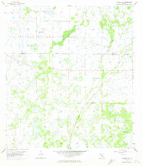
1956 Map of Murdock NW
USGS Topo · Published 1973About this map
Myakka River State Park dominates the northern landscape of this interior Florida survey, where the wet prairie environment is defined by an intricate network of slow-moving drainages. Low-lying features like Mossy Island Slough and Deer Prairie Slough illustrate the natural hydrology of the region before significant modification. The map documents the early transition of this wilderness, recording the Big Slough Canal cutting through the marshland to manage water levels. Traces of previous human activity are visible in the Old Railroad Grade and several scattered Flowing Wells, marking the efforts of early ranchers or timber interests to utilize this portion of the Manatee and Sarasota County border. The 1972 revisions captured in purple show the initial expansion of roads into the area, hinting at the suburban development that would eventually reshape this wetland corridor.
Find a feature on this map
9 named features on this map. Tap any name to fly to it.
Don’t see what you’re looking for? This feature index may not catch every label — zoom into the map to look around manually.
Map Details
Editions of this 1956 Murdock NW Map
3 editions found
Other maps of this area

1944 · Lower Myakka Lake
USGS Topo · 1:31,680

1944 · Myakka River
USGS Topo · 1:31,680

1944 · Miakka
USGS Topo · 1:31,680

1956 · Murdock
USGS Topo · 1:24,000

1956 · Myakka City
USGS Topo · 1:24,000

1956 · Edgeville
USGS Topo · 1:24,000

1956 · Murdock SE
USGS Topo · 1:24,000

1956 · Murdock NE
USGS Topo · 1:24,000

1956 · Murdock NW
USGS Topo · 1:24,000

1956 · Tampa
USGS Topo · 1:250,000