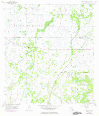
1956 Map of Murdock NW
USGS Topo · Published 1977About this map
Myakka River State Park encompasses a significant portion of this landscape at the Manatee and Sarasota County line, characterized by an intricate network of wetlands and seasonal watercourses. The presence of an Old Railroad Grade cutting across the northeastern section provides a tangible link to former industrial or transport routes through these wetlands. Natural drainage patterns are dominated by the Deer Prairie Slough and Mossy Island Slough, which weave through the marshy terrain alongside the Lake Mud Slough. This mid-century survey also records several locations marked Flowing Well, indicating the hydrological characteristics and early water management of the area. Further south, the landscape is modified by the Big Slough Canal and various other canals, showing the transition from natural sloughs to engineered drainage systems.
Find a feature on this map
11 named features on this map. Tap any name to fly to it.
Don’t see what you’re looking for? This feature index may not catch every label — zoom into the map to look around manually.
Map Details
Editions of this 1956 Murdock NW Map
3 editions found
Other maps of this area

1944 · Lower Myakka Lake
USGS Topo · 1:31,680

1944 · Myakka River
USGS Topo · 1:31,680

1944 · Miakka
USGS Topo · 1:31,680

1956 · Murdock
USGS Topo · 1:24,000

1956 · Myakka City
USGS Topo · 1:24,000

1956 · Edgeville
USGS Topo · 1:24,000

1956 · Murdock SE
USGS Topo · 1:24,000

1956 · Murdock NE
USGS Topo · 1:24,000

1956 · Murdock NW
USGS Topo · 1:24,000

1956 · Tampa
USGS Topo · 1:250,000