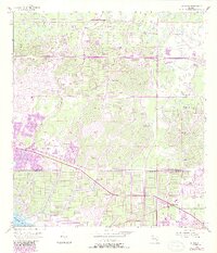
1956 Map of Murdock
USGS Topo · Published 1987About this map
North Port and the village of Murdock define this mid-century Florida landscape, showing a period of transition as grid-patterned residential developments began to overlay the natural hydrology of the Gulf Coast. The survey highlights the significant drainage network of Big Slough, which winds southward toward the Myakka River at the southwestern corner. Local landmarks of the era include an Airway Beacon and a Golf Course, reflecting the early infrastructure of this growing community. A notable geographic feature, Little Salt Spring, appears as a unique hydrological point within the burgeoning street grid. The map also documents numerous instances of Flowing Wells, indicating the high water table and the importance of groundwater access for the area's development. This edition includes purple-tinted updates that reveal the rapid expansion of the North Port Corporation Boundary across the Sarasota and Charlotte County line.
Find a feature on this map
13 named features on this map. Tap any name to fly to it.
Don’t see what you’re looking for? This feature index may not catch every label — zoom into the map to look around manually.
Map Details
Editions of this 1956 Murdock Map
3 editions found
Other maps of this area

1944 · Lower Myakka Lake
USGS Topo · 1:31,680

1944 · Myakka River
USGS Topo · 1:31,680

1956 · Murdock
USGS Topo · 1:24,000

1956 · Murdock SE
USGS Topo · 1:24,000

1956 · Murdock NE
USGS Topo · 1:24,000

1956 · Murdock NW
USGS Topo · 1:24,000

1956 · Englewood
USGS Topo · 1:24,000

1956 · Tampa
USGS Topo · 1:250,000

1956 · Charlotte Harbor
USGS Topo · 1:250,000

1957 · El Jobean
USGS Topo · 1:24,000